Best Motorcycle Trips In North America
Updated on | By Dushyant Yadav

There is something fascinating about motorcycle touring. The desire to get on and travel the country or perhaps the fact that you see the world in a completely different way gives you a sense of freedom mixed with the excitement to encounter the nature from the back of your motorcycle. When you’re on two wheels you feel the change in weather, you long for the shade, and elate when you feel the first drop of rain on your face. The twists, turns, hills and dips all these riding affairs make the journey venturesome.
There is just something about getting on the motorcycle, loading up all your gear, figuring out what you can and can’t fit, strap it all down to your motorcycle and throw your leg over it to hit the open road. It’s just an awful lot of fun and we all enjoy the long trips. It’s a dream that we think most motorcyclists have it in their bucket list.
The day you first passed your riding test and went straight to the dealer to buy a beginner’s motorcycle, you had a dream to get on it and do that cross-country journey. The wind, the freedom, the adventure, and the curiosity of encountering new riders that may eventually become a lifelong friend makes the joy of riding a lot more memorable as compared to a dull car trip. While not all roads are similar, there are some that are worthy enough to be checked under your bucket list. So here we are with our list of best motorcycle roads in America.
Top 10 Best Motorcycle Roads In North America

The Jeb Stuart Highway (U.S. Route 58)
Our entire list of top 10 motorcycle roads is filled with spectacular landscapes; however the first one to mention here is the Jeb Stuart Highway or ‘The Mighty Python’. There are many roads that we could have included from the Appalachian mountain region, back of the dragon, or the snake; but the section of US58 starting at Virginia 16 and heading west into Damascus is the perfect blend of curves and beautiful scenery. Hit the road at the right time and you would probably find no one! Although it is possible to get caught behind a sloth, but don’t let it spoil your mood. There are approximately 318 curves in just 33 miles and once you reach Damascus, make sure you stay in a resort. There are cheaper places in town as well but none with great bar and restaurant.

Death Valley
The driest place in the USA, the lowest point in North America, and one of the hottest places on Earth; Death Valley is one of the USA’s most extreme road trips. It’s just a five hour ride from Los Angeles, or a three hour ride from Las Vegas. Many parts of Death Valley are designated Wilderness Areas and are under the care of the National Park Service. Despite its rugged appearance, Death Valley’s ecological, geological and historical gems are fragile. Tread lightly, so future generations can experience the wilderness value of this national treasure as well. If you’re approaching from Nevada, the adventure begins just outside the park in the unconventional town of Beatty, The Gateway to Death Valley.
What makes Death Valley a truly daunting landscape for riders is a seemingly endless expanse of flat cracked earth that covers more than 200 square miles! Commonly known as Badwater Basin, the floor of this valley is actually salt made by the surrounding mountains making the ride extremely challenging and adventurous.

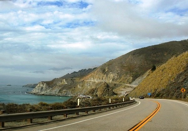
Pacific Coast Highway
The Pacific Coast Highway running from Half Moon Bay to Albion (California) is one of those Holy Grail rides in North America that is filled with fantastic views of the Pacific Ocean. Our personal favorite is the one that runs from Half Moon Bay just south of San Francisco over the Golden Gate Bridge and ends in Albion. Leaving Half Moon Bay you will enter the San Francisco traffic as you cross the Golden Gate, but once you have left the city, this part of Pacific Coast Highway will run through Muir Woods over sand beach dunes and through small coastal communities as it winds its way along the coast of the Pacific Ocean. Don’t be in a rush on this route because morning fog is quite common here, and so is the traffic. If you want a real treat and don’t mind the high priced accommodations near the beach, stay at the beach side inn and enjoy their delicious cuisines. They are quite delightful and can give you one of the best lodging experiences.
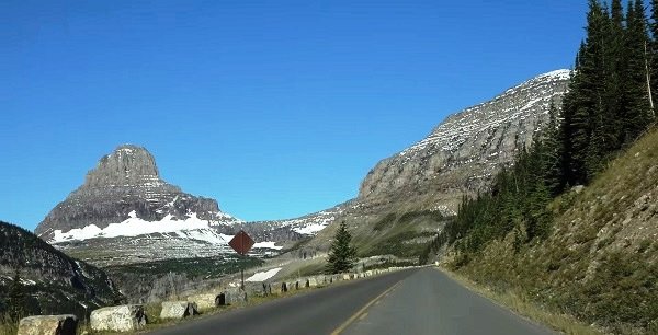
Going-to-the-Sun Road
Going-to-the-Sun Road in Glacier National Park (Montana) is one of those mountain roads that do not become fully passable until late June of every year. Going-to-the Sun Road is highly recommended because the landscapes are something you must experience to believe. No photograph can ever justify the magnificence of this enchanting place. The road was completed in 1932 and it still remains a spectacular 50-mile two-lane paved road that spans the width of glacier. It passes through many types of terrain including glacial lakes, cedar forests, and alpine tress. In 1983 Going-to-the Sun Road was for the first time included in the National Registry of Historic Places and in 1985 it was made a National Historic Civil Engineering Landmark.
Angeles Crest Highway
Angeles Crest Highway that runs through the San Gabriel Mountains national monument and Angeles national forests of southern California. Riding through this rural mountainous terrain you would never believe that you are only 60 miles outside of the crowded greater Los Angeles area. The Angeles Crest Highway or California Route 2 is filled with spectacular views and twisty turns. This is one of those rides where you need to focus given that loose rock can be found in any of the tight turns along its 66 mile length. Some of Route 2 is often closed for repair but the detour is equally as spectacular. Angeles Crest Highway began construction in 1929 and was intended to be a fire access road. It was finally completed in 1956 after a pause for World War II. Today it is one of America’s great motorcycle roads.
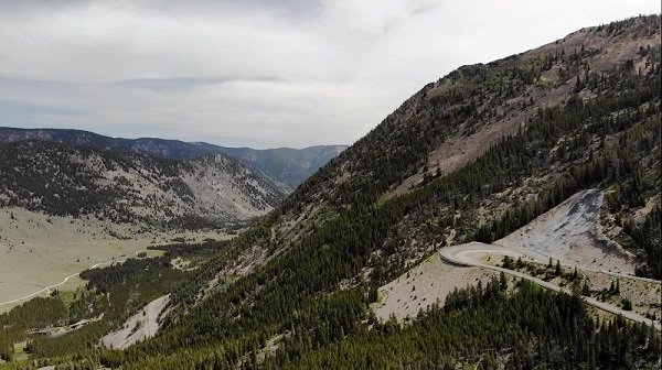
Beartooth Highway (U.S. Route 212)
Beartooth Highway (U.S Route 212) running from the north eastern entrance of Yellowstone to Red Lodge (Montana), this road will take you up to more than ten thousand feet in height where you will find snow even in the month of July. The road usually opens in the month of June and is filled with spectacular views. Be warned to keep your eyes on the road and enjoy the splendid beauty while you cruise through the road. The descent down towards Red Lodge is equally breathtaking. The highway gets its name from the jagged rock features that resemble a bear’s sharp tooth. An interesting fact about Beartooth Highway is that it climbs to the highest highway elevation in two states that is in Montana at 10,350 feet and in Wyoming at 10,947 feet. The Beartooth Highway truly deserves its moniker as an All-American road.
Million Dollar Highway (U.S. Route 550)
The Million Dollar Highway or U.S. 550 runs from Durango (Colorado) to Ouray (Colorado). While this road can is heavily trafficked, the scenery is spectacular and the road just twisty enough to keep it interesting. This is a route on which you probably do not want to lose your focus because if you do, you just might find yourself several thousand feet down a steep cliff running north to south. The route is adventurous and challenging, you will even find yourself on the edge of a sheer drop off with literally no guard rail! This extreme route is amongst the most dangerous roads in North America. The stretch of highway between Durango and Silverton is part of the San Juan Skyway. The Million Dollar Highway is actually a 25 mile segment of the skyway that runs between Silverton and Ouray (Colorado). The road climbs three mountain peaks; Coal Bank Pass at 10,610 feet, Molas Pass at 10,912 feet and Red Mountain Pass at 11,018 feet. It is a belief that the highway got its name because of the million dollar expense incurred to build each mile, the truth however no one really knows.
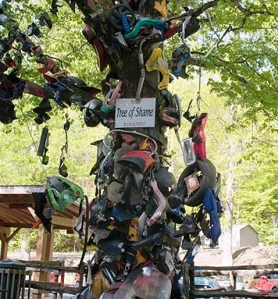
The Tail of the Dragon (U.S. Route 129)
The section located alongside Deals Gap on the North Carolina–Tennessee state line is most commonly known as The Dragon or The Dragon’s Tail and if you’re looking for it on a map, it’s U.S Route 129. The road runs around the Great Smoky Mountains in the Cherokee National Forest and has no intersecting roads or driveways. Unbelievable but true!
It’s a solid 11 miles with 318 curves. That might not sound like a particularly long ride, especially if you’re not out on the East Coast. But trust us when we say that this road is one of the best in the world.
See also: Best motorcycle tours in the World
This ride is definitely for the more experienced riders out there, so if you’re a nubcake, we suggest hitting up the nearby Cherohala Skyway or Blue Ridge Parkway instead to prep yourself.
To give you an idea about the difficulty; there is actually a ‘Tree of shame’ where people put parts from all the busted motorcycles that go down out there. So make sure you are prepared before you venture out for this adventure.
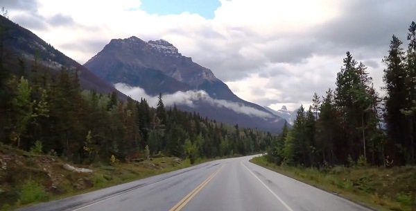
Icefields Parkway
When talking about North America and not particularly the United States, Icefields Parkway is probably the best motorcycle route of North America. With each passing curve you will find an even more spectacular view than the last. Till date we have never met a rider who has captured less than hundred photographs while riding on this route. The parkway runs from Lake Louise to Jasper (Alberta, Canada) over the course of its 232 kilometers or 144 miles it winds along the continental divide through soaring rocky mountain peaks, ice fields, and vast sweeping valleys. The Icefields Parkway is dotted with more than 100 ancient glaciers cascading waterfalls and amazing emerald lakes. You will owe it to yourself once you have ridden this route.

U.S. Route 66
The Mother Road, Main Street USA, Will Rogers Highway, those are the other names for U.S Route 66. When people think of Route 66 they think of the song, they think of the TV show, they think about a road trip. Back in the old days, Route 66 defined the meaning of a road trip; it literally filled the soul of a traveler with zeal and gave meaning to the word ‘Americana’. Too bad that it didn’t last very long since Highway bypasses were built to help travelers get around congested areas and to shorten travel time. You can still travel along Route 66 on the interstate and even some of the original alignments of the highway. There are many preservation activities going on to preserve the history of route 66, so future generations would know what a real road trip actually meant.
5 Best Adventure Motorcycle Routes In USA

Big Bend National Park
For the dirt lovers we have the Big Bend National Park in Texas. If you are visiting this place make sure to get some experience of Ghost Town by spending couple of nights in Terlingua, just outside of the National Park. Big Bend is home to River Road, a route that travels through and across many desert washes. So if you own a sturdy bike, crossing this road won’t be a problem. Another interesting thing you will experience while you are on this road is that, once you get off the main two lane highway that runs from Terlingua to Presidio, it’s basically just one giant off road playground.
If you are a beginner and looking for an off road route, then this is a great place to learn and have fun. We recommend bringing some jerry cans along in case you need a refill as there are no gas stations between Terlingua and Presidio.

Bighorn National Forest (U.S. Route 14)
Ride towards U.S. Route 14 and you will find Wyoming’s Bighorn National Forest. Traveling east from Greybull Wyoming, you will start at the bottom of a beautifully carved canyon and eventually you will climb above the clouds (literally). Along the way you will see spectacular views that my look fictitious. The Bighorn National Forest covers more than 1.1 million acres and is one of the oldest government protected forest having been created in 1897. An interesting fact is that the forest was first created with the name Big Horn that is two words and then in 1908 through an executive order of Teddy Roosevelt, it was changed to a single word Bighorn. Regardless of the name it is a place of great beauty and diversity. Make sure you stop at Shell Falls to take few pictures of the amazing gushing water.

Peak to Peak Highway
Peak to Peak Highway is a 55 mile stretch between Allenspark and Nederland and runs through some pretty staggering elevation with an average height of about 9,300 feet! So if you’re riding a small bike, you might have some issues if you decide to take this road. The best thing to do while covering this route is to ride till you reach a pass and then halt to witness the beauty along the side of the road. You will pass through ghost towns, abandoned gold mines, silver mines, hiking trails, and even off road trails. Be warned though, if this is your first riding experience at this altitude, you may feel a bit lightheaded and exhausted. It is highly recommended to give yourself an extra day before hitting the road. This will give your body enough time to acclimatize and get used to the thin air. This is a difficult route making it quite popular among the young. You might come across a lot of travellers if you visit during the peak season.
Coastal Route 1 (U.S. Route 1)
Coastal Route 1 is a nice and long highway that provides a scenic alternate to Interstate 95. This is a proper long ride that stretches around 526 miles filled with staggering views. However, If you just want to do the Coastal Route (portion along the ocean), you can cover the 290 miles long and beautiful stretch of twisty roads that passes through small towns and villages. Autumn is definitely the best time to ride; do pack some cold weather gears and waterproof layers of jackets while you head here. Aside from the weather, the road itself is not difficult, seeing as how it’s mainly highway riding. So if you’re a beginner looking to get some miles under your belt, Coastal Route 1 is a great way to do it.
Lewis and Clark Highway (U.S Route 12)
The Lewis and Clark Highway is more commonly referred to as Lolo Pass. For you history buffs, this road closely follows the route taken by the Lewis and Clark Expedition to cross the newly acquired western portion of the country after purchasing Louisiana in 1803. It is also one of the best adventure motorcycle routes in America.
U.S. 12 follows the Lochsa River as it twists and turns its way through amazing valleys and deep gorges; there is no single spot on this route that you will not find spectacular. The Lolo trail was by far one of the most difficult passages for the Lewis and Clark expedition. The party had to hack their way through thick timber and haul their canoes in parts over the steep mountain ridges. Fortunately for a motorcycle rider, the journey is lot smoother and you have ample amount of time to enjoy the breathtaking scenery that used to amaze those early explorers.
Scenic Motorcycle Routes Across America
Sometimes you just have to leave your monotonous routine to decompress from the grind of daily life. Heading towards scenic highways is certainly one of the best ways to do it. It is our belief that it’s the journey and not the destination that counts. Agreed that flying is great and certainly has its advantages, but you certainly miss witnessing God’s natural creation. In this article you’ll see some scenic roads that you may want to experience for your next road trip so sit back relax and enjoy reading as we take you on a journey to some of the best scenic highways in United States.
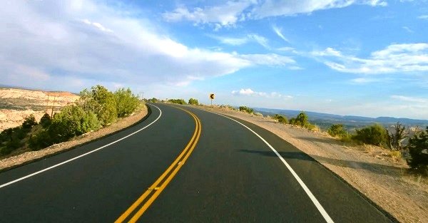
Scenic Byway 12
This one is not actually a single road but we just had to include this ride in our list because the desert landscape which it passes through literally gives Goosebumps! The 144 mile route between Hanksville and Bryce canyon travels through Capitol Reef National Park, Escalante National Monument and ends just outside of Bryce Canyon National Park. Along the way you will ride through some of the most beautiful and surreal landscapes you can imagine. Utah 12 (Highway 12) is also known as ‘A Journey Through Time Scenic Byway’ since the place is surrounded by landscapes that were formed by water and air erosion millions of years back. Like many of the roads on this list Utah 12 is designated as an All-American road.
North Cascades Highway
A staggering 436 miles of sheer beauty, the North Cascades Highway (originally the North Cross State Highway) is probably the most delightful highway in America. If you haven’t experienced it yet, you should visit this splendid highway all the way from the Skagit Valley. Along the way you’ll see Diablo dam and Gorge Dam which were created to provide energy for the city of Seattle and behind them are some beautiful emerald green Lakes where travelers come to fish and recreate on a daily basis.
There are many places you can go in America and travel on some beautiful highways but nothing absolutely nothing compares with a cross state highway in Washington State. If you are looking for a scenic road trip through the Pacific Northwest then consider the ride along the Cascade loop in Washington. This curvy route takes you through some of Washington’s most spectacular scenery. Most riders start from Seattle, making their way through Snohomish River and Stevens Pass before going through the gorgeous Tumwater Canyon leading into Leavenworth.
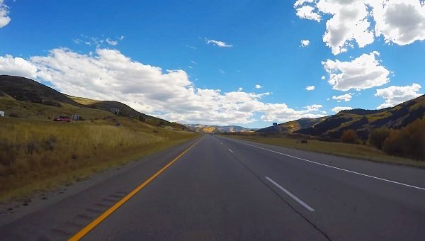
Interstate 70
Interstate 70 is an engineering marvel along the Colorado River from Grand Junction to Denver. It’s great in the summer but even more spectacular during the winter. Unlike many of our previous scenic highways that experience a lot of road closures due to winter storms I-70 for the most part remains open.
It passes through the Eisenhower Tunnel which is the longest tunnel and highest point in the interstate highway system at an elevation of 11,158 feet. As it crosses the Continental Divide there are many vistas and scenic spots to pull off and enjoy the beauty.
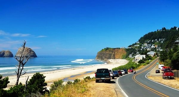
Oregon Coast Highway
It is 363 miles from the Washington border to the California border. Natural beauty and wildlife adorn the shoreline with soaring sand dunes, pristine beaches, and bustling harbors. It’s completely open to the public with plenty of lodging, fast food, goods and services along this highway. Moreover it has more wildlife as compared to the Pacific Coast Highway.
The color of water is more vivid and on any sunny day the beauty is just breathtaking. It generally takes 10 to 12 hours to ride the full length of this highway. As you go further to the South you generally find it less crowded and a more rugged coastline with abundant redwoods.

Redwood Highway
The Redwood Highway of Northern California is a 175 miles long stretch that begins at the California-Oregon border near Crescent City and extends to Leggett. This highway at times runs along the coast that provides great views of the Pacific Ocean and when you ride through the inlands, it will be covered with redwoods. Some of these trees are the tallest living things on our planet reaching 300 to 350 feet high. Just incredible!
Due to their height they look skinny but that is deceiving because there are a massive 16 to 18 feet in diameter, due to which some areas you will have a narrow winding road while the rest will be proper four-lane highway.
Further reading: Best motorcycle tours in India